Who Oversees Flood Control for Montgomery County?
January 2020
By Matt Barrett, Flood Management Division Engineer
Concerns about lack of flood mitigation in Montgomery County are in the news again (Montgomery County commissioners respond to accusation of lack of flood mitigation efforts, The Courier, October 25, 2019; Montgomery County commissioners respond to concerns over lack of flood mitigation, Community Impact News, October 23, 2019). With all the attention in the media, Montgomery County residents may ask, "Who oversees flood control for Montgomery County?"
Throughout its existence, in addition to providing water supply and other similar services, the San Jacinto River Authority (SJRA) has engaged in planning efforts related to flooding in its home base of Montgomery County, however county-wide flood mitigation plans have not been realized for a number of reasons including a lack of a dedicated funding source and a broad consensus to implement county-wide flood mitigation plans.
Creation of the San Jacinto River Authority
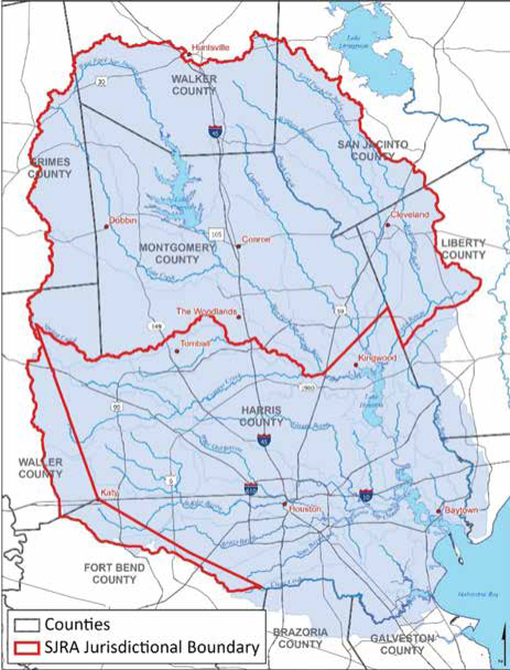
The SJRA was created by the Texas Legislature in 1937 to develop, conserve, and protect the water resources of the San Jacinto River basin—all without funding from the State of Texas. Covering all or part of seven counties, the organization's jurisdiction includes the entire San Jacinto River watershed, excluding Harris County. SJRA is one of 10 major river authorities in the State of Texas, and like other river authorities, its primary purpose is to implement long-term, regional projects related to water supply and wastewater treatment across various counties in Texas. As defined by its enabling legislation, SJRA also has the authority to provide flood control and numerous other activities within its jurisdictional boundaries. SJRA actively seeks grant funding for projects, participates in regional watershed planning across its seven county area, and recently implemented a Flood Management Division to coordinate with various political subdivisions and partners on studies and funded projects.
Creation of the Harris County Flood Control District
The same year SJRA was created (1937), the Texas Legislature also established a flood control district in Harris County. The Harris County Flood Control District (HCFCD) was created with the Harris County Commissioners Court as the District's governing body. Funded by a dedicated ad valorem property tax collected by Harris County, the HCFCD is the single entity dedicated to providing flood damage reduction plans and maintaining flood reduction infrastructure in Harris County.
The Current State of Affairs
Montgomery County does not have a single entity like HCFCD to implement flood damage reduction plans, construct and maintain flood reduction infrastructure, and fund these efforts with a dedicated source. Instead, Montgomery County Commissioners Court, Montgomery County Engineering Department, Montgomery County Office of Homeland Security and Emergency Management, Montgomery County Flood Plain Management, SJRA, various working groups, and local water districts all contribute their specific solutions to combat flooding which results in the current shotgun approach to flood mitigation.
A Preview of the Past
Dedicated funding and a dedicated governing body, such as a flood control district, could make mitigation projects easier to devise, implement, and monitor. It could also improve oversight and provide a coordinated effort to improve the entire county, not just those areas that may have more active and politically engaged residents.
Historical Planning Efforts: Assessing Risk Since the 1940s
Beginning at its creation in 1937 and continuing through more than eight decades of dedicated and professional leadership, SJRA has quietly, but diligently, pursued its goals of long-term water planning and providing water-related services.
Beginning in 1943, in response to flood damage to property and agricultural lands in the San Jacinto River watershed, several historical drainage studies were performed. These studies analyzed existing conditions, identified flood risks, and evaluated mitigation alternatives in order to reduce flood risk, manage water supply in the region, and determine sedimentation impacts.
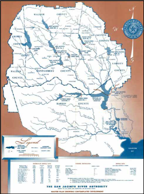
The initial 1943 San Jacinto River master plan report called attention to the need for comprehensive flood risk assessment within the service area. The ultimate goal of the master plan was the conservation, reclamation, and utilization of the natural resources of the entire watershed while accounting for sustainable growth and development within the area. A prime objective of the plan was to address flooding issues, resulting in several projects being considered to reduce the area's flood risk: the creation of dams and reservoirs, channel improvements, and levee construction. A total of 14 dams with approximately 886,000 acre-feet of storage for water supply and flood mitigation were considered in the Plan. The estimated cost of these projects at the time was approximately $22.2 million for dam/reservoir construction and $1 million for channel improvements.
In the 1957 San Jacinto River master plan report update, the Authority again discussed the importance of flood risk reduction measures as well as the implementation of drainage improvements to reduce inundation and destructive run-off, and minimize future loss of land productivity. Similar alternatives to those outlined in the 1943 master plan were discussed, and a detailed list of alternatives and estimated costs was again provided.
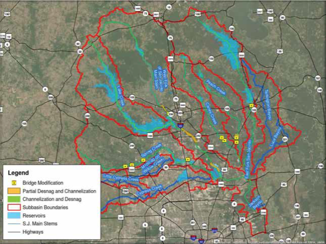
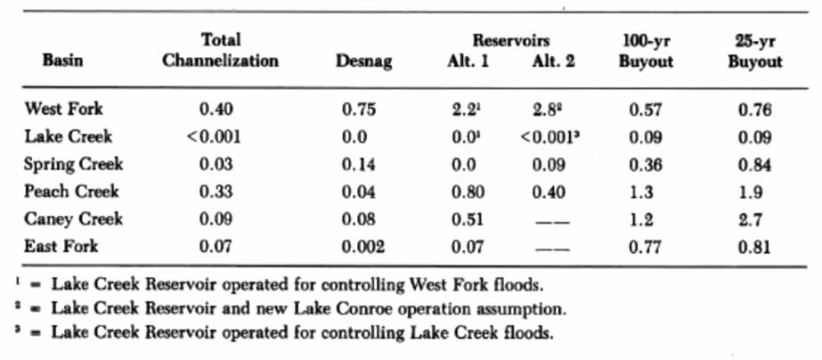
A San Jacinto Upper Watershed Drainage Improvement and Flood Control Planning Study developed in 1985 was the first study that focused on detailed evaluation of proposed alternatives and incorporated hydraulic modeling to evaluate their feasibility and flood risk reduction effectiveness. Several alternatives, both structural and non-structural, were considered and evaluated, including:
- Total channelization
- Selective channelization
- Vegetation clearing
- Bridge modifications
- Property buyouts
- Lake/reservoir creation
The report concluded that total channelization, bridge modification, and most vegetation clearing appeared to be less feasible based on benefit/cost ratios, and that property buyouts and reservoir construction appeared to be most cost effective.
In 1989, a Comprehensive Flood Protection Plan for Southern Montgomery County, Texas was created. This plan determined existing flood problems, proposed flood reduction alternatives, and recommended improvements for a small portion of south Montgomery County. The analyzed and recommended alternatives addressed localized flooding as opposed to regional issues.
SJRA, in cooperation with the Bureau of Reclamation, studied the possibility of building a reservoir on the lower portion of Lake Creek and developed a report in 1997. The proposed reservoir would have been roughly 80% of the size of Lake Conroe. The reservoir was proposed to increase surface water supply (approximate yield of 60% of Lake Conroe water supply), with no floodplain mitigation. Plans for the reservoir were not further pursued due to a lack of federal and state funding and minimal interest in water sales from the proposed reservoir.
Find out more on the SJRA BLOG at SJRA.com
Dedicated funding and a dedicated governing body, such as a flood control district, could have made mitigation projects easier to devise, implement, and monitor over the years. It could have also improved oversight and provided a coordinated effort to improve the entire county. A number of studies and plans were prepared over the years, but they were not implemented due to lack of funding.
On the SJRA Blog we will further explore the history of flood planning and flood management. We look at the attempts by a local legislator and the SJRA to establish a Montgomery County Flood Control District and how these efforts ultimately failed when the Montgomery County voters defeated the establishment of the district and its recommended funding mechanism. Find out more about the history of flood control in Montgomery County as well as additional water topics on https://www.sjra.net/blog/.
One of the major river authorities in Texas, SJRA's mission is to develop, conserve, and protect the water resources of the San Jacinto River basin. Covering all or part of seven counties, the organization's jurisdiction includes the entire San Jacinto River watershed, excluding Harris County.
 Source: Flood Management Division Engineer